


Les Molieres

petergole
User
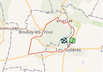

Length
6.5 km

Max alt
179 m

Uphill gradient
93 m
Km-Effort
7.8 km

Min alt
112 m

Downhill gradient
93 m
Boucle
Yes
Creation date :
2020-07-14 12:11:44.0
Updated on :
2020-07-14 13:53:40.439
1h41
Difficulty : Unknown

FREE GPS app for hiking
 SityTrail
IGN / Geographical institutes
SityTrail Plus
The world is yours!
About
Trail Walking of 6.5 km to be discovered at Ile-de-France, Essonne, Les Molières. This trail is proposed by petergole.
Positioning
Country:
France
Region :
Ile-de-France
Department/Province :
Essonne
Municipality :
Les Molières
Location:
Unknown
Start:(Dec)
Start:(UTM)
431407 ; 5391515 (31U) N.
Comments